Sunday, January 25, 2009

Meandering looking at gold mining history and more New Zealand high country

The weather has been so unsettled this summer break, and with this and my son's part time job, we've not done the longer tramping trips I had in mind pre Christmas, however this means we just utilise the camper truck to good advantage and use local weather knowledge to minimise exposure to heavy rain and strong winds.

So a few days ago we travelled an old favourite of mine: the road from Cromwell to Garston, which essentially takes you from Central Otago's dry golden climate, through serious winter snow high country to pastoral Southland province. The route follows the Nevis valley and involves about 24 river crossings - challenging, if not crazy for a car, but not too serious for a judicially driven four wheel drive.

First stop - to catch a fish...
nevis400-1.jpg

An hour or two later we're deep in gold mining history - this was once a gold dredge pond...
nevis400-2.jpg

nevis400-3.jpg

With a weather forecast predicting heavy rain I once again thought it wise to get the river crossing out of the way and camp on the saddle above Garston. This was the landscape we woke up amongst...
nevis400-4.jpg

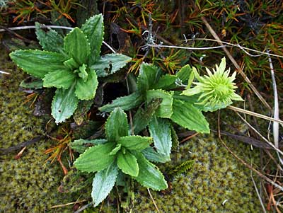
Before descending we spent a few hours wandering about exploring the unique New Zealand High Country landscape photography potential before the rain came in again. This first photo below is a Spaniard plant - sadly they proliferate where there has been too much burning off at the expense of snow tussock and soil values. They're unpalatable and the ends of the leaves are like hypodermics...
nevis400-5.jpg

nevis400-6.jpg

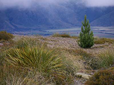
This lone pine, a noxious weed in this landscape, intrigued me and sensing a photo I hounded it, but did not get the shot I'd hoped for, so interestingly I "let go" of the idea and wandered elsewhere, but coming back the same way I made this "grab shot", and as is often the case when the mind is freed of labeling and preconceived ideas it turned out to be the one capturing the essense I had in mind...
nevis400-7.jpg

A very youngNew Zealand Pipit, which I think maybe quite rare, but I'm not sure as they frequent the high snow tussock areas which by nature are very "open", and I've never seen one this close ever before despite all the time I've spent in this environment. They can also be mistaken for the Skylark. I did get much closer for more photos, but I like this first one as it shows something of the nature of the bird's environment...
nevis400-8.jpg

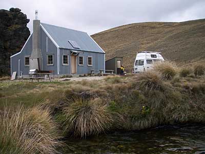
On the descent, and heading post-haste to the tea rooms that I love to have a coffee at in Athol, the track goes past the old and historic Southland Ski Club hut...
nevis400-10.jpg

nevis400-9.jpg

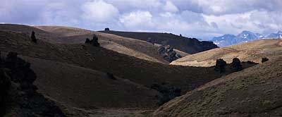
I have a thing about the land forms of this part of Southland - maybe it's the contrast to the flat land, or maybe it's because being near The Nokomai there is a genetic link with my ancestors who were born there and frequented the area...
nevis400-11.jpg

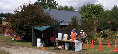
The rain caught up with us so we drove back via Queenstown and got home early to dryer climes. It was the day of the huge and growing annual Challenge Wanaka race, and as Mike a neighbour was one of the helper/organisers he had a drink station opposite the house. The race went on until midnight so we had quite different noises and energy in the neighbourhood for a few hours...
nevis400-12.jpg

Note: Phil Lloyd commented on posts relating to the Nevis Valley and gold mining, and has since been in touch via email. Here is his story:

"I spent two summer holidays in the 1970's with Lex Maclean and his parents working a goldmine just after the gorge in the upper Nevis. His parents were quite elderly even then and had moved to Milton after the population in the Nevis had dwindled away but they still came back to work the mine each summer.

I met up with Lex in Clyde last winter and he said they have no photos of those days, despite having many travellers call in and take photos.

I undertook to try to track down some of those photos but have had no luck so far."

If you can help Phil please contact him:

+64 9 573 0421 or Phil.Lloyd@visy.co.nz

Labels: , , , , , , , , ,

Share |

Sunday, January 18, 2009

Using one's imagination with landscape photography

Since my blog last week was a tad wordy in discussing Cascade Saddle my effort this week is decidedly pictorial, and the shots are basically the result of work done on myself to "see" things differently in relation to New Zealand landscape photography - from the eyes of a human through to those of a bee!

I've filed them under "abstract" and here I'm resisting labeling them so you can let your imaginations get some exercise like mine did to make them! If you have any emotional responses I'd love to see a comment, and I'm sure this would be of interest to other readers as well.

ab1.jpg

ab2.jpg

ab3.jpg

ab4.jpg

This is my favourite - I like the way the blurriness to the left and the right takes my eye on a journey into the background...ab5.jpg

ab6.jpg

ab7.jpg

ab8.jpg

ab9.jpg

Labels: , , ,

Share |

Sunday, January 11, 2009

Cascade Saddle Mt Aspiring National Park

Last Sunday I had the opportunity to take a few more shots while helping search for a missing tramper [Irina Yun - now presumed drowned - if you wish to read a comprehensive overview of the scenario then Bob McKerrow a highly respected and experienced NZ mountaineer has compiled an overview on his blog].

The Cascade Saddle is actually the low point on the middle to top right of this photo. The original route way back in the days of my boyhood was called the "Ernie Smith route" if I recall correctly, and it was replaced by improving on what was to be a new evolving [safer?] route known as the "Cullers Route" which exited higher up at or near where I took this photo at "the Pylon". The current incarnation and improvements of that line descends from this point to the Cascade Stream [or river - take your pick], and then ascends again to the Cascade Saddle. Yes, lots of ups and downs, but an infinitely more straightforward route on relatively easier ground [as long as it's not wet]...
cascade400-0.jpg

All week I have been pondering the sad fact that far too many people have died or come to grief in this "hard country", which can be so delightful on a good day, yet diabolical in any other sort of conditions, especially those featuring rain, wind or snow.

I don't recall the exact date as again it would have been when I was a youngster, but a person went missing in the bluffs back then, and a Royal New Zealand Air Force pilot by the name of Christopher Johnson was called on to search, and he did in a Harvard fighter plane, but unfortunately crashed and perished in the lower Cascade Stream, and so the initial tragedy was compounded! He has had a glacier named after him, but this is a sad "2nd best" to a life lost in the prime...

Of course I never knew Christopher, but I was to get to know people who knew and loved him, and I often have reflected how life would have worked out differently for many had he not perished at such a young age. On another level at the time of this tragic event he'd already had quite an influence on the climbing scene of the day in the NZ Alpine Club, where my outdoor skills were nurtured by those who knew him too. We live in a funny world of connectedness!

A sample of the terrain we searched between the Cascade Saddle and the Pylon...
cascade400-3.jpg

Cascade Stream [which has to be crossed - and shelter is a scant commodity if you cannot] drops maybe 500 meters vertically where it goes out of sight in this photo. A drop so awesome it's totally beyond capture on camera, however there is a taste of it about five photos down...
cascade400-4.jpg

Plunket Dome, despite the easy accessibility from the Saddle it's not frequented often - maybe it's the cumulative distance...
cascade400-5.jpg

Upstream view of some of "our task" to poke our noses into: up Cascade Stream - some wild country and big...
cascade400-6.jpg

The last time I was on a Search and Rescue mission on the Cascade Saddle route back in about the late 1980s, was when we were responding to the fact that early one morning a young student had run down to Aspiring Hut and raised the alarm. His companion had slipped on snow the evening before and slid head-first into some rocks just above bush-line sustaining head injuries. He'd got her [unconscious] onto safe flat ground somehow, then erected their tent, and he'd looked after her all night essentially ensuring a clear airway in a situation where he could not sleep. Our pick-up was far from simple as we had to carry her across the same 30 degree ice/snow she'd slipped on. The Jet Ranger, which at least was "shut-down" on an area the size of it's skids precisely on the very edge of a vertical drop-off into the bluffs, was a welcome sight on our return! I'm glad it was not windy, and it could park up, 'cause it could well have been!


Our helicopter heading into the Dart Glacier to pick up one of our group - we had to wait quite sometime for our pickup and we discussed anything but what we'd have to do if it could not make it back before more cloud drifted in and night became a reality, not just a promise...
cascade400-7.jpg

The Dart Glacier again - on the right is the drop off for Cascade Stream as mentioned earlier...
cascade400-8.jpg

Mt Rob Roy, second only in height in the area to Mt Aspiring which is hiding on the left...
cascade400-9.jpg

Plunket Dome as the sun sets...
cascade400-10.jpg

I've only touched on three tragedies on this route, but there have been countless others despite education attempts and warnings. In fact at least 3 people, with significant local knowledge advised Irina to not attempt the crossing in heavy rain - especially not alone. Regularly there is a theme of disregard for conditions accompanied by a goal deemed to be pressing! Search and Rescue personal do their best in what are all-to-often "fine" [in every sense of the word] scenarios heightened by short weather windows, for time is of the essence!

Experience and respect for weather and terrain with good team work and decision making is essential and I'm posting this blog to bring these concepts onto the radar of all those who browse the web for information, while planning to enjoy our amazing New Zealand mountains and landscapes!

The comments of Marg, one of my blog readers says it nicely:

"It is a grim reality that no matter how awe inspiring , beautiful and breathtaking the mountains are we would be fools to ever call them friends or expect the elements to deal kindly to us just because we expect it to be so. I am so dreadfully sorry that these beautiful photos are inspired by a search and rescue operation. It makes the sights all the more staggering and also more reverent I suppose if that is the right word."


Some points for people to keep in mind when planning some tramping in New Zealand:

1] The terrain in geological terms and weather is far more dynamic than most realise - even those with experience in other countries fail to grasp this! History repeatedly reinforces this in the minds of us Kiwis dedicated to education and Search and Rescue [as far as I'm concerned the latter is in the "ambulance at the bottom of the cliff" catagory - it's better we're all on the top!]

2] Just because high profile [irresponsible?] travel guides tout gems of trips to promote readership, don't believe what you read. Seek local advice! The Dept of Conservation and New Zealand Mountain Safety Council are great resources.

3] Make sure all experiences a small ones, and thus survivable. The big ones don't enhance learning [maybe in the next life]!

4] All actions, or in-actions in life have consequences. If we're traveling alone in New Zealand mountains expect those consequences to be dramatic if we're not mentally prepared and "trained up".

5] Be very aware of our capabilities, and the potential for good and bad times on New Zealand walks. I've seen too many in our hills with one foot on a banana skin and the other one in the grave! The sad thing to observe is that there is often no self perception of the lack of knowledge and experience.

6] In retrospect many of us have been "saved" by bad weather. By this I mean we have all had ill conceived ideas, but never had the chance to try them because the weather intervened!

7] Leave a record of intentions [I find the written word to be best]. This is called "signing in", so be it with the Dept of Conservation or a friend or whomever, don't forget to sign out! If I'm doing a solo trip I plan it well and make the plan part of the intentions. On the trip I always do my best to stick to this plan [which often will incorporate a backup or retreat option], so that if anything happens I've left the best clues possible behind. I'd also leave messages en-route, and if things were getting tough I'd leave even more e.g. an arrow made of stones or sticks incorporating my name.


Wanaka bound...
cascade400-12.jpg

This was another memorable mountain day in the New Zealand Southern Alps, but I would have much rather have had a different reason to be in this area once again! A nice quiet trip in light airs and sunshine with my son, with lots of rests, light fluffy clouds and good cheer, with time to indulge in some serious landscape photography would be my pick for a perfect crossing!


Sharks Tooth from the air...
cascade400-11.jpg

Labels: , , , , , , , , , , , ,

Share |

Sunday, January 4, 2009

An interesting start to the New Year what with some varied outdoor activities

New Years day started for me watching fireworks down on Lake Wanaka's lake shore at midnight. I've always found Eely Point a good vantage point as it's not over-run by people. Before the day was out though I was deep in the heart of our Southern Alps on a Search and Rescue mission: an Aucklander of Uzbekistan descent was tramping alone from the Aspiring Hut to the Dart Hut over the Cascade Saddle, a tough alpine tramping route near Mount Aspiring, and not turned up at Dart Hut well over the other side.

A few light moments shared in the helicopter over the Matukituki river before arriving at the saddle...
sar400-1.jpg

I was far too busy after landing to photograph and admire the amazingly tough environment of Cascade Saddle and Dart Glacier we'd just been transported into as if by magic at over 1700 meters, until waiting to be picked up again in failing visibility with snow flakes. It was good to be "out-of-there" a few minutes later knowing darkness and a "weather bomb" were arriving...sar400-2.jpg

Jan. 2nd as anticipated was a shocker for weather, and so no searching occurred. The next day I'd committed to helping with the half marathon "Souther Muster" being held at the Snow Farm. At 1500m we did get some left-over snowflakes from the big storm, but it was a lovely day, be it cool with the freezing level at about 1600m.

My camper beside Meadow Warming hut where we ran a drink station for the runners and bikers for the morning...
muster400-2.jpg

muster400-6.jpg

Runners calling in for drinks, bananas or jelly beans...
sthmuster400.jpg

After the job was over there was time for a 3 hour walk and some serious landscape photography of the typical New Zealand high-country variety...
muster400-4.jpg

muster400-5.jpg

muster400-7.jpg

As of finishing this my weekly dispatch, the weather remains unsuitable for further searching for the tramper. It may be days before an outcome is achieved which will be hard for the search management team and the victim's family members.

PS just as I posted this the ph. rang and I find myself getting ready for another flight to Cascade Saddle [perhaps!]. Watch this space.

Labels: , , , , , , , , , ,

Share |