St Bathans Range and Twin Burn Run
For forty years I've stood on many a mountain top in Canterbury and Otago and been able to see the huge expanse of the St Bathans Range, so imagine my delight when I was able travel it's whole length yesterday. Yes, like many I've contemplated traversing it on foot, by ski or vehicle, but even to get to the start is a mission in it's own right. My destiny was for it to be via 4wd.
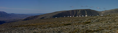
The first major stop for the group was to look at an alpine cirque close up and have a welcome walk-about before tackling the forth-coming, extremely bumpy and rough alpine section. To the left [nor east] is the Hawkduns, and St Mary's range, from the summit of which I know you can see Banks Peninsula, so as we're higher here I dare-say it'd be possible with binos. Further to the left and across the headwaters of the Manuherikia is the back of Otematata Station, childhood home of my cousin Deirdre. Further to the left again was Mt Cook...
A tele-shot of some vehicles with Mt Cook in the background...

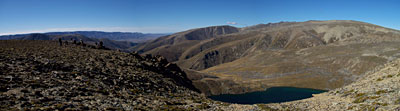
An unexpected alpine lake nestled in a unique glacial cirque setting with surrounding bluffs...
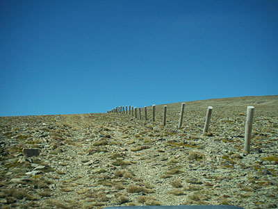
A smooth part of the track showing the fragile alpine vegetation just below 2000 mts above sea level, and weathered fence posts that are now destined for removal under the new land tenure...
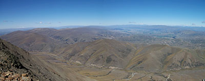
Like being in an air plane... here we look south down from the summit of the range at nearly 2100 mts. onto Dunstan Crk. which flows left to St Bathans. In the background tending right is one of the agriculturally developed Lindis river flats, which the main road passes through en-route to Queenstown and Wanaka. On the extreme left horizon it'd probably be possible with binos to see Saddle Hill which is just south of Dunedin...
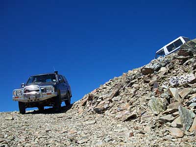
Cousin Michael eases his lead 4wd vehicle around the most [mentally] taxing corner on the route. The drop off to the left is just as strong as the terrain on the right indicates. Each vehicle had to stop with it's nose over the drop-off, and reverse up the 30 degree incline to take a second bite at the corner. A situation that calls for cool nerves...
The tops were too windy for lunch and besides this high country farm hut had a drop [pit] toilet. So out came the deck chairs and the billy tea...

For 15 years cousin Michael and his friends in North Otago Search and Rescue have organised 4wd trips in our local mountains as fund raisers. Typically 20 to 120 vehicles will pay to come. The idea being that the route and permission is all organised. This run [high country farming area] Twin Burn has just been purchased by the New Zealand Dept of Conservation for $NZ4.8 million so there was much discussion by the group just how this amazing addition to the Crown Land Estate will be managed and what degree of access will be possible for recreation etc.
Our trip of 24 Kms took more than several hours inc. lunch and some photo stops, one puncture [amazingly good for 40 + vehicles in such extreme terrain], and we travelled at above 2000 meters for about an hour.
Cousin Michael, who with other members of North Otago Search and Rescue have over 15 years taken in excess of 7000 people into our local mountains in four wheel drives. In this shot, taken on the day as per above, we traversed the whole of the background ridge from right to left...

The first major stop for the group was to look at an alpine cirque close up and have a welcome walk-about before tackling the forth-coming, extremely bumpy and rough alpine section. To the left [nor east] is the Hawkduns, and St Mary's range, from the summit of which I know you can see Banks Peninsula, so as we're higher here I dare-say it'd be possible with binos. Further to the left and across the headwaters of the Manuherikia is the back of Otematata Station, childhood home of my cousin Deirdre. Further to the left again was Mt Cook...
A tele-shot of some vehicles with Mt Cook in the background...
An unexpected alpine lake nestled in a unique glacial cirque setting with surrounding bluffs...
A smooth part of the track showing the fragile alpine vegetation just below 2000 mts above sea level, and weathered fence posts that are now destined for removal under the new land tenure...
Like being in an air plane... here we look south down from the summit of the range at nearly 2100 mts. onto Dunstan Crk. which flows left to St Bathans. In the background tending right is one of the agriculturally developed Lindis river flats, which the main road passes through en-route to Queenstown and Wanaka. On the extreme left horizon it'd probably be possible with binos to see Saddle Hill which is just south of Dunedin...
Cousin Michael eases his lead 4wd vehicle around the most [mentally] taxing corner on the route. The drop off to the left is just as strong as the terrain on the right indicates. Each vehicle had to stop with it's nose over the drop-off, and reverse up the 30 degree incline to take a second bite at the corner. A situation that calls for cool nerves...
The tops were too windy for lunch and besides this high country farm hut had a drop [pit] toilet. So out came the deck chairs and the billy tea...
For 15 years cousin Michael and his friends in North Otago Search and Rescue have organised 4wd trips in our local mountains as fund raisers. Typically 20 to 120 vehicles will pay to come. The idea being that the route and permission is all organised. This run [high country farming area] Twin Burn has just been purchased by the New Zealand Dept of Conservation for $NZ4.8 million so there was much discussion by the group just how this amazing addition to the Crown Land Estate will be managed and what degree of access will be possible for recreation etc.
Our trip of 24 Kms took more than several hours inc. lunch and some photo stops, one puncture [amazingly good for 40 + vehicles in such extreme terrain], and we travelled at above 2000 meters for about an hour.
Cousin Michael, who with other members of North Otago Search and Rescue have over 15 years taken in excess of 7000 people into our local mountains in four wheel drives. In this shot, taken on the day as per above, we traversed the whole of the background ridge from right to left...
posted by Donald at
9:36 PM
![]()
![]()

1 Comments:
All this adventuring! I don't know when you get time to work - or do I just work too much? Sorry I haven't visited for a while, just recovering from the flu at present.
Post a Comment
Subscribe to Post Comments [Atom]
<< Home